![podaris_logo_png.png]](https://support.podaris.com/hs-fs/hubfs/podaris_logo_png.png?height=50&name=podaris_logo_png.png)
A Streets project holds a road and street network that Podaris uses for routing. Attach one to a Plan project and your bus routes, isochrones and journey planning follow that network instead of the default.
This article covers getting the network in. Once it is built you can change it link by link inside Podaris, which is covered in Editing a Street Network.
Three ways to start
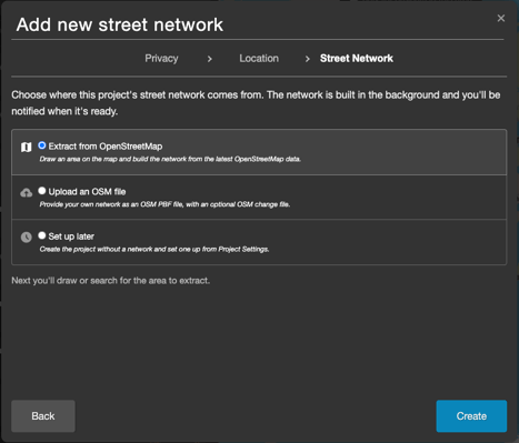
When you create a Streets project, the Street Network stage of the create-project window asks where the network should come from.
| Option | Use it when |
| Extract from OpenStreetMap | Almost always. You draw an area on a map and Podaris builds the network from current OpenStreetMap data. No external tools, no file hunting. |
| Upload an OSM file | You already have a prepared network, for example a corrected extract or one edited in JOSM, and you want to use it as the starting point. |
| Set up later | You want the project to exist now and will choose a source from Project Settings afterwards. |
Whichever you pick, the network is built in the background. You can close the tab and carry on with other work, and you will be notified when it is ready.
Extracting an area from OpenStreetMap
- On the Podaris home screen, click New and choose Streets.
- Set the name, privacy and location as usual.
- At the Street Network stage, leave Extract from OpenStreetMap selected and click through to create the project.
- A map window opens, titled Extract street network from OpenStreetMap. Search for a place, or draw the area you want as a rectangle, circle or polygon.
- Click Extract.
Podaris then downloads that area from OpenStreetMap, compiles it for routing, and lands you on the Setup Streets page so you can watch progress.
[GIF: Searching for a place in the extract window, drawing a polygon around it, and clicking Extract.]
Choosing the right area
Draw for your whole area of analysis, not just the part you plan to change. If you intend to run 45-minute drive-time isochrones from a site, the network needs to cover everywhere reachable in 45 minutes, or the contours will stop at the edge of your extract.
At the same time, do not extract a whole country when you need a town. Larger areas take longer to build and are slower to edit.
Note: An extract must be a single area of no more than 100,000 km². If you draw more than one shape you will be asked to keep just one, and if the area is too large Podaris tells you its size and the limit before anything is queued.
Uploading your own OSM file
Choose Upload an OSM file at the Street Network stage, then pick your files.
| File | Accepted formats | Maximum size |
| Network | .osm, .osm.pbf, .osm.bz2, .osm.gz | 500 MB |
| Change file (optional) | .osc | 30 MB |
The change file is applied on top of the network file, so you can supply a base extract plus a set of edits made elsewhere.
Tip: You no longer need an external editor to make changes. If your only reason for preparing a file outside Podaris was to add or alter roads, extract the area instead and make those changes with the street editor, where they are versioned, undoable and easy to revise.
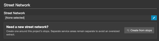
Creating a network from an existing project's stops
If you already have a Plan or Network project and want a street network sized to it, you can build one without leaving that project.
- Open the project and go to Project Menu > Settings.
- Find the Street Network section and click Create from stops.
- Give the network a name and set the buffer around each stop. The default is 1 km and the range is 100 m to 50 km.
- Click Create street network.
Podaris draws a boundary around every stop in the project, creates the Streets project, queues the extract, and selects the result as this project's street network in one step. It reports how many stops the boundary was derived from.
Separate service areas stay separate rather than being merged into one large rectangle, so a network built from a county-wide feed with three towns in it covers three areas rather than everything in between.
Watching the build
Whatever the source, the Setup Streets page in Project Settings shows progress. If you extracted from OpenStreetMap, the first stage will say "Extracting street network from OpenStreetMap." Then, building a network involves several stages, and the page names the current one with a progress bar.
You do not need to stay on the page. Podaris notifies you when the network is ready.
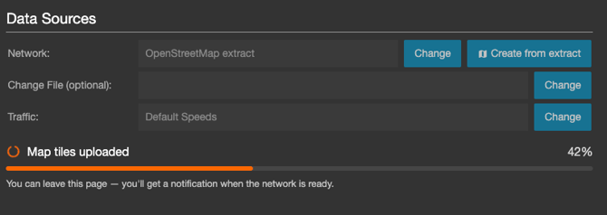
The same page is where you change the source before a build has started. The Network row has a Change button for uploading a file and a Create from extract button for drawing an area, and there is a Change File (optional) row for an .osc. When you are happy, click Finish Setup.
Checking the result
On success the page confirms that your street network is built and ready to use, and offers Open in Plan to start working on it.
Network Information reports what was actually built. It is worth a look the first time, and any time routing results surprise you:
- Routable ways and routing nodes: the size of the network the router will use. A number far smaller than you expected usually means the drawn area was smaller than you intended.
- Elevation: whether terrain data was included. Without it, cycling and walking results ignore gradient, which matters in hilly areas.
- Coverage bounds: the extent of the network, useful for confirming it reaches far enough for your longest isochrone.
- Source nodes, source ways and routing edges: the underlying counts, mostly useful when raising a support ticket.
Common errors
- The build failed. Click Retry on the Setup Streets page. If it fails again, contact support@podaris.com with the project link.
- Isochrones stop at a straight edge. The extract does not cover the area being reached. Create a new Streets project with a larger area.
- Routing ignores hills. Check Network Information for elevation coverage.
- The upload was rejected. Check the format and size against the table above. Very large national extracts often exceed 500 MB, in which case extracting the area you need is the easier route.
Next steps
- Editing a Street Network: change roads, add links, apply interventions.
- Street Network Versions & Scenarios: publish your edits and keep parallel scenarios.
- Streets Projects: what a Streets project is and how to attach one to a Plan project.