![podaris_logo_png.png]](https://support.podaris.com/hs-fs/hubfs/podaris_logo_png.png?height=50&name=podaris_logo_png.png)
Podaris:Plan
Importing Layers & Data Library Access
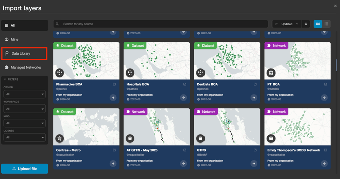
- Import layers: Click the Import button at the top of the Layers panel toolbar. This opens the asset library (titled Import layers), where you can search, preview, and add transport networks, datasets, GIS files, or
.podarisfiles directly into your project as a copy. - Data Library: The Data Library is now accessed directly within the asset library via the Data Library tab on the left sidebar, giving you access to Podaris-curated census, boundary, and point of interest (POI) datasets.
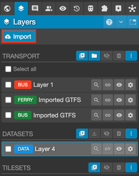
Transport Layer Management Actions
 |
Add a new transport layer. Note that new layers will be added to your Base View, but will not be added to any other views. |
 |
Create layer group. Existing layers can be dragged and dropped into a group, allowing you to organise related layers. |
 |
Toggle layer visibility. |

|
Delete selected layer(s). |
 |
Further options, including duplicate transport layers. |
Dataset Layer Management Actions
|
Create a new dataset layer. |
|
|
Download dataset layer as either .GeoJSON, Shapefile or KML |
|
Toggle layer visibility. |
|
Delete selected layer(s). |
 |
Further options, including duplicate dataset layers, as well as add datasets from OpenStreetMap |

Tileset Layer Management Actions
 |
Add tileset layer |
|
Toggle layer visibility. |
 |
Delete selected layer(s). |
|
Further options, including duplicate tileset layers. |
General Layer Management Actions
- Make a layer active by clicking on it.
- Edit layer properties by clicking the gear icon or double-clicking the layer.
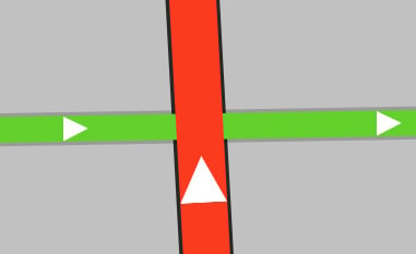
- Re-order layers by dragging them up or down the layer list. By zooming into intersecting control lines, you can see the stacking order of these layers:
Layer Properties window
- Change Layer Title and Color
- Change LayerType
- Change custom properties -- Depending on the selected layer type, you can override certain parameters with custom values. This requires a paid account.
Streets Project
The Layers Panel is also visible in Streets Projects.
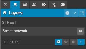
Although much shorter than the Layers Panel in Podaris:Plan projects, it allows the following functions to be undertaken:
Street Layer Management Actions
 - Toggle street network visibility.
Tileset Layer Management Actions
|
Add a new tileset layer. |
|
Toggle layer visibility. |
 |
Delete selected layer(s). |
|
Further options, including duplicate tileset layers. |