
The Snapshot Tool button, when clicked, will frame an area of your map that can be exported as a high resolution image by clicking the export button on the Snapshot Tool panel. The area within the snapshot preview window can be panned and zoomed to your requirements.
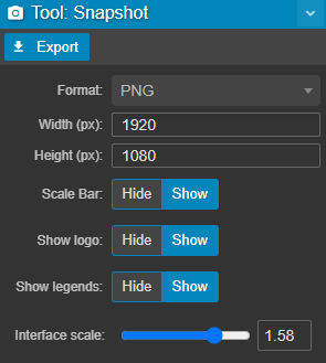
| Format | Lossless PNG (larger file size, better image quality) or JPG (compressed, smaller file size, lower image quality) |
| Width/Height | Total size in pixels |
| Scale Bar | Exports (or hides) the scale bar in the bottom left corner of your map |
| Show logo |
Displays your organisation's logo in the top left of the snapshot |
| Interface scale |
Scale up or down logo, scale bar, legends, etc... |
You can also hide/show legends in the basemap tab of the display settings.