![podaris_logo_png.png]](https://support.podaris.com/hs-fs/hubfs/podaris_logo_png.png?height=50&name=podaris_logo_png.png)
Once a street network has been built, you can change it directly in Podaris. Draw a new footbridge, close a street to through traffic, turn a road into a bus gate, ban a right turn, or retag a whole area at once, then see what it does to routing and accessibility.
Open a Streets project and click Open in Plan, or open it from the home screen as you would any other project.
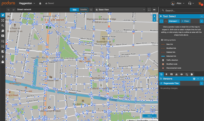
How editing works
Two things are worth understanding before you start:
- Edits are pending until you rebuild. Everything you change is held as a pending change and shown on the map straight away, but routing, isochrones and analyses keep using the last published version of the network until you rebuild it. This is deliberate: it lets you make a complete set of changes and publish them together. See Street Network Versions & Scenarios.
- Deleted links stay visible until you rebuild. A link you delete is marked for deletion and drawn in the "deleted" style rather than disappearing. It is still there so you can change your mind.
Edits go through undo and redo like any other Podaris change, and each one is recorded so you can see later who changed what.
Links and junctions
A street network is made of links (the stretches of road, path and cycleway) and junctions (the points where they meet). Each link carries a set of tags, which is what the router reads to decide who may use the link and how fast.
These are OpenStreetMap concepts, and Podaris keeps the underlying OpenStreetMap identifiers, so a link imported from OpenStreetMap shows an OSM # link in its panel that opens the same object on openstreetmap.org. Links and junctions that Podaris created have no OpenStreetMap identity and show no link.
You do not have to learn the tags. Every field in the editor has an information button explaining what it does to routing and linking to the reference, and the presets in the Select tool apply whole sets of tags for common interventions in one click.
The toolbar
A Streets project has its own toolbar. The tools share names and shortcuts with the Plan tools but they are different tools doing different jobs. Read the individual tool articles to understand how to use them to edit your street network.
| Tool | Key | What it does |
| Select | S | Inspect and edit links, apply interventions, reshape geometry, and edit many links at once |
| Select, on a junction | S | Junction type, splitting, roundabouts and turn restrictions |
| Street Draw | D | Draw new links |
| Street Erase | X | Delete a whole link, or erase part of one |
| Route Preview | Route a journey between two points by car, bus, cycle and foot to check what your edits changed | |
| Compare | Show every difference between two scenarios, grouped into added, retagged and removed | |
| Isochrone | I | Travel-time contours on this network. The same tool as in Plan, trimmed to walking, cycling and driving, with Road Network locked to Streets |
| Pan, Zoom, Measure, Comments | 2, 9, M, C | The usual navigation and collaboration tools |
Pressing Esc cancels whatever a tool is part-way through, and pressing it again returns you to Select.
Seeing what you have changed
When nothing is selected, the Select panel shows an Editing symbols key covering new, modified, deleted and selected links, traffic direction arrows, and modified and disconnected junctions.
For a wider view, open Display Settings and find Street Network. There you can turn junction nodes, point features and street labels on or off, and colour the whole network by:
- Road class, to check the hierarchy is right
- Speed limit
- Motor vehicle access, the fastest way to see your modal filters and bus gates as a pattern
- Surface
- Cycling provision
The colouring is saved per view and updates as you edit, so you can watch a scheme take shape. A legend appears on the map.
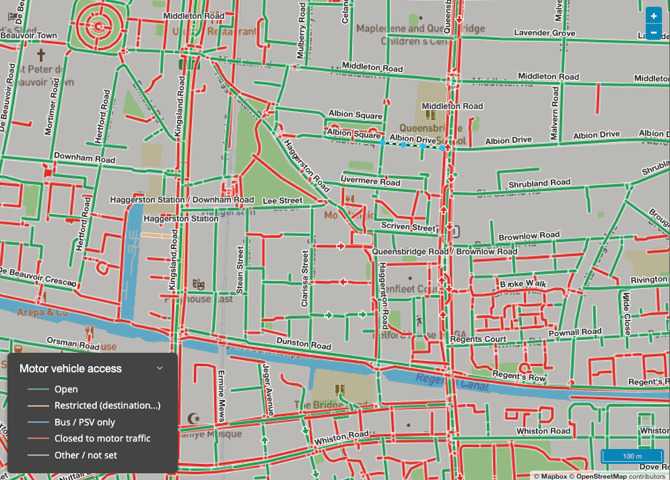
In Display Settings, you can also change whether to show labels, junctions, and point features (for example, pedestrian crossings).
Warnings to watch for
Podaris checks your edits as you make them and reports problems in the alert manager.
| Level | Warning | Usual cause |
| Error | Disconnected or dangling nodes | A junction left with nothing attached after a deletion. |
| Error | One-way contraflow conflicts | Two one-way links running in opposite directions that do not share a junction. |
| Warning | Very short links, under 2 m | An accidental double-click while drawing. These can make routing unstable. |
| Warning | Overlapping links that do not share a node | A new link drawn across an existing one without snapping to it, so the router cannot turn between them. |
| Warning | Missing bridge or tunnel tags on crossing links | Two links cross on the map but at different levels. Add a bridge or tunnel tag under All tags to say so. |
When you have finished editing
Open the Versions panel and rebuild the network. Until you do, nothing you have changed affects routing. Streets projects do not have a history panel.
The same panel is where you keep parallel scenarios, compare two versions of the network, and go back to an earlier one. See Street Network Versions & Scenarios.