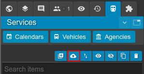
Importing transport networks
Existing transport networks can be imported from a range of industry formats including GTFS, TransXchange (TXC) and NetEX. To import a new network, select the "import" button from the services panel:
Imported files must be provided in the .ZIP format and have a maximum size limit of 250mb. You may wish to consider removing unneeded trips or unused routes from your feed to reduce its size if you meet this limit.
Podaris converts all imported files into GTFS, meaning that you may use Podaris to import a TXC file before exporting it as GTFS, for example.
GTFS Import Options
The default options are designed to import a feed in a way where it provides accurate routing for journey planning and isochrones. If you are importing a feed to analyse attributes like fleet size or to modify routes, you may wish to modify the import options below.
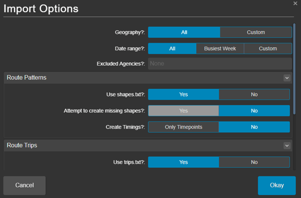
Geography
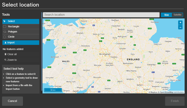
Selecting custom polygons allows you to either draw one or multiple polygons, so that only routes contained within those regions are imported. You may also import a shapefile (as .geojson, .kml, etc) in order to use the polygons contained within for this purpose.
Selecting all geographies will import routes from any region specified in your GTFS feed.
Date Range
- All - All dates within the GTFS feed
- Busiest Week
- Custom - Dates within a starting and ending range expressed in YYYY-MM-DD
Exclude Agencies
The Exclude Agencies drop down menu allows you to exclude from import any agencies that you have already specified in your project.
Route Patterns
- Use shapes.txt - the path along which your vehicle will travel. Described as 'patterns' in Podaris. See the GTFS shapes.txt specification.
- Yes - This gives you the option to create missing shapes. This is disabled by default and is a manual process that we can assist with if needed.
- No - This assumes the bus pattern type will be used and allows you specify if the pattern is:
- Auto - that it follows existing road infrastructure
- Manual - that it follows hand-drawn infrastructure within Podaris
Route Trips
- Use trips.txt
- Use frequencies.txt
- Trips without frequencies.txt
- Skip
- Create exact trip - for rows in trips.txt that do not have a frequency.txt mapped to them, this option will cause Podaris to create trips on the route that have the exact departure times of each trip.
Exporting GTFS Feeds
General Transit Feed Specification (GTFS) is one of the most common open-standard data formats for public transport information schedules, making it a popular format for continuing to share and edit networks outside Podaris.
Once you have created a transport network or made changes to an existing network, you may wish to export it using the GTFS feed export function in Podaris to:
- Edit a GTFS feed
- Add route shapes and geometry for a feed that doesn’t have one
- Create a smaller extract from a larger feed i.e. for an area of a single agency
- Convert a feed with frequency-based trips to trips-only
- Convert a TransXChange file to a GTFS-file
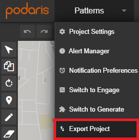
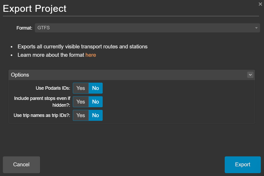
GTFS feeds can be exported in Podaris:Plan from the Export Project menu, accessible from the Project Menu, selecting the GTFS format.
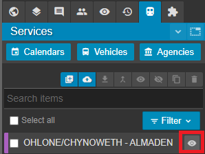
Only currently visible transport routes and stations will be exported. The visibility of routes and stations can be toggled on and off with the Hide/Show button (shown below for routes).
Before exporting, you will be asked to specify three export options, these are:
- Use Podaris IDs? When you import a network into Podaris, services are given a Podaris ID as well as their ID from the original GTFS. This setting allows you to choose which ID will be exported. Select ‘yes’ to override any agency, stop and route IDs from the original GTFS. The exported GTFS will instead have unique ID’s, generated from Podaris. Select ‘no’ if you want to retain the original GTFS agency, stop and route IDs.
- Include parent stops even if hidden? Within Podaris you are able to group stations, making individual stations “children stations” with a “parent station” for the group. This setting allows you to decide whether these parent stations should be included in your outputted GTFS. Including parent stations can be useful when networks contain complex stations with multiple platforms, or which serve multiple routes, and you want to be able to simplify the network for further analysis.
- Use trip names as trip IDs? When combined with the “Create individual trips?” option available when importing a network, this setting allows you to export the network with the same trip IDs as the imported GTFS.
Further Help
Our support team can help you get your transport networks imported in a way that best serves your use-case. For more information about the GTFS format, please visit GTFS.org.