Isochrones Overview
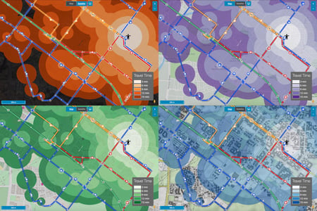
Isochrones depict areas on a map accessible from a certain point within a set travel time or distance. Isochrones in Podaris can be one of two kinds:
- Travel time - this type of isochrone calculates the accessibility to or from one or more locations on a given day at a given time. When combined with datasets through queries, you can answer questions such as:
- “How many residents can access hospitals within 15, 30, 45 minutes using the public transport network?”
- “How many jobs are accessible from this housing development at 9 am on a Monday?”
- Access time - these can be used to analyse the catchment of a route, sets of stations, or cycling infrastructure. Access time isochrones can help you answer questions like:
- “How many people live within a 10 minute walk of stops along a bus route?”
- “What is the average income of people who live within the catchment of bus stops in Belfast?”
- “How many schoolchildren can access a bus stop within 5 minutes of walking?”
Using Isochrones
The number and size of the steps are configurable through the Tool Properties panel. Station-to-station travel times are calculated per the Station matrix, while radiuses around the station assume a standard walking speed (crow-flies distance).
Note that for stations to be accessible to the isochrone, they must be connected to and reachable through the network.
Isochrone tool properties
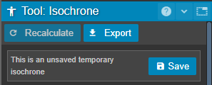
| Recalculate | Update isochrone after changing a property |
| Export | Export isochrone geometry as GeoJSON, shapefile or KML or export query results as csv. |
| Save |
Save current isochrone. Saved isochrones can be recalled and operated on in a variety ways from the isochrone tool panel. |
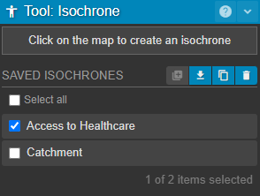
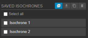
Saved Isochrones
Saved isochrones can be selected from the isochrone tool panel - clicking the name of a saved isochrone other than the one that you are viewing, will restore it.
Clicking on the name of the currently active isochrone will dismiss that isochrone. The ![]() button has the same effect, and creates a new, unsaved isochrone.
button has the same effect, and creates a new, unsaved isochrone.
| Create a new isochrone. | |
|
Download selected isochrone as either:
|
|
| Duplicate saved isochrone | |
| Delete saved isochrone |
Travel Time Isochrone Properties
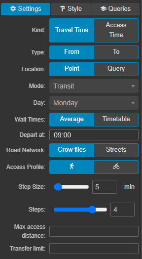
| Type | From/To as set by the departure/arrival times respectively |
| Location |
|
| Mode |
This is the primary mode for the isochrone and can be set as:
|
| Day | Day of the week, taking into account services running in your project. |
| Depart/Arrive at | (Impacted by From/To type, respectively). Time of day the journey begins or ends. |
| Road Network |
|
| Access Profile* | This can be set when Mode is set to Transit. It selects the means by which people travel to bus and train stops on your network and forms the way the first and last mile of their multi-modal public transport trips are made.
|
| Step Size |
Isochrone step size in minutes |
| Steps | Number of steps |
| Max Access Distance | Set a limit on the maximum walking/cycling access distance |
| Transfer Limit | Set a limit on the maximum number of public transport legs, for example, a transfer limit of 1 would allow one bus journey with no changes. |
* For the street-based cycle isochrone we account for speed changes as a result of underlying elevation and road type-specific speed restrictions, however, the default speed for a flat normal road is 13mph.
Drive time isochrones using the car profile are currently in public beta. Unlike journey's found through bus planning or the simulation engine, these do not take into account historical data by default. Instead, they assume free-flow speeds using the posted maximums.
Access Time Isochrone Properties
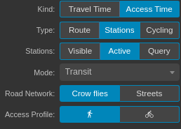
| Type | |
| Stations |
When the type is set to stations, this property allows you to choose which stations to include in your access time isochrone:
|
| Route | When the type is set to "route", this allows you to select a specific route to create an access time isochrone for. |
| Mode |
This is the primary mode for the isochrone and can be set as:
|
| Road Network |
|
| Access Profile |
|
| Step Type | Either time or distance |
| Step Size |
Isochrone step size in minutes |
| Steps | Number of steps |
* For the street-based cycle isochrone we account for speed changes as a result of underlying elevation and road type-specific speed restrictions, however, the default speed for a flat normal road is 13mph.
Step and Styling Properties
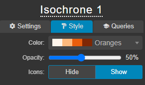
| Color | Color scheme |
| Opacity | Isochrone opacity |
| Icons | Show or hide 'stickman' icons in centre of isochrones |
Styling properties allow for isochrones to be rendered in many different ways:
Pinned isochrones
Isochrones can be pinned to specific Views, allowing them to be shared with others -- including stakeholders using Podaris:Engage -- as well as captured in snapshots.
When creating a new view, the currently active isochrone will be pinned to that view. Note that if you make any changes to the location or properties of an isochrone while it is pinned, these changes will be saved to the view.
Views with pinned isochrones are indicated by the presence of an "isochrone man" icon on its entry in the Views panel.

Selecting and Deselecting Saved Isochrones
Isochrones can be selected and deselected using the tickboxes next to the isochrone's name. At the bottom of the list of your isochrones, the number of selected isochrones and the total number of isochrones are visible.
The 'Select all' tickbox will select or deselect all isochrones. Clicking between two isochrones in the list while holding SHIFT will also select all other isochrones in between.